
Trip outline
Dates: 3 to 10 June 2023
Location: Hotel Sous l’Olivier, Buis-les-Baronnies, 170 Chemin du Menon, 26170, France. https://hotel-buislesbaronnies.com/
Contact: +33 4 75280104, hotelolivier@wanadoo.fr
The trip overview document can be found here
Hotel Sous l'Olivier
Key information
| Destination | Distance | Elevation gain | Route link |
|---|---|---|---|
| Poet-en-Percip | 27 km | 703 m | 27 Percip |
| Sainte Jalle | 30.9 km | 703 m | 31 Jalle |
| Faucon | 33.0 km | 538 m | 33 Faucon |
| Mollans sur Ouveze | 33.6 km | 480 m | 34 Mollans |
| Saint-Saveur | 41.0 km | 835 m | 41 St-Saveur |
| Gorges d'Ubrieux | 49.2 km | 870 m | 49 Ubrieux |
| Ventoux up and down | 52.1 km | 1,400 m | 52 Ventoux up-down |
| Malaucene | 61.6 km | 895 m | 62 Malaucene |
| Montbrun-les-Bains | 59.7 km | 850 m | 60 Montbrun |
| Mirabel | 65.1 km | 1,093 m | 65 Mirabel |
| Nyons | 64.0 km | 1,096 m | 64 Nyons |
| Remuzat | 71.5 km | 1,544 m | 72 Remuzat |
| Sederon | 77.1 km | 1,221 m | 77 Sederon |
| Gorges d'Ubrieux | 80.8 km | 1,090 m | 81 Ubrieux |
| Vaison-la-Romaine | 86.1 km | 1,139 m | 86 Vaison |
| Villedieu | 86.6 km | 1,169 m | 87 Villedieu |
| Ventoux (via Sault) | 106.6 km | 2,207 m | 107 Ventoux via Sault |
| Eygalayes | 109.9 km | 2,104 m | 110 Eygalayes |
| Ventoux (via Malaucene) | 112.5 km | 2,446 m | 113 Ventoux via Malaucene |
| Gorges de la Nesque anticlockwise | 114.5 km | 1,720 m | 115 Nesque |
| Gorges de la Nesque clockwise | 119.8 km | 1,744 m | 120 Nesque clockwise |
| Gorges de la Nesque | 122.8 km | 1,452 m | 123 Nesque |
| Col de Sausse | 124 km | 2,830 m | 124 ColdeSausse |
| Around Ventoux | 124.7 km | 1,799 m | 125 TdVentoux |
| Ventoux (via Bedoin) | 125.5 km | 2,738 m | 126 Ventoux via Bedoin |
| Tour de Ventoux (France velo, needs edit to start and finish) | 128 km | 2,586 m | 128 TdVentoux |
| Col de Lure | 185 km | 3,353 m | 185 Lure |
| Blauvac (add to other routes to access this TdF climb with great views) | 9.8 km | 209 m | Blauvac |
| Day / date | Time | Detail | Location | Comments |
|---|---|---|---|---|
| Sat, 11 April | 1305 | Bus to hotel from airport | Hotel Hoposa Uyal | Mallorca Holiday Transfers, exit 7 by Pons Delgado office |
| 1400 | Easy afternoon ride | La Victoria | ||
| Sun, 12 April | 0830 | Porto Cristo | ||
| Mon, 13 April | 0830 | Cap Formentor and Cala Sant Vicenç | ||
| Tue, 14 April | 0830 | Sa Calobra | ||
| Wed, 15 April | 0830 | Inca | ||
| Thu, 16 April | 0830 | Orient | ||
| Fri, 17 April | 0830 | Port Soller | ||
| Sat, 18 April | 1030 | Bus transfer to airport |
| Attraction | Information | Distance from hotel |
|---|---|---|
| Via Ferrata St Julien | Via Ferrata climbing, Baronnies Sport | 4 km |
| Les Gorges du Toulourenc | Wild swimming or hiking along the river Drome | 17 km |
| Malaucene | C10 village with Wednesday art and clothes market. Best views are from Calvaire in the old town. | 23 km |
| Montbrun-les-Bains | Spa treatments overlooking the mountains. Medieval frescoes in C14 church. | 29 km |
| Nyons | Sunday market with local fruit, honey and cheese. Old town with C14 bridge. | 31 km |
| Sault | Hilltop village overlooking lavender fields. Medieval castle and ramparts. Charming boutiques. | 38 km |
| Orange | Historic Roman town with open-air theatre, museum. Lunch at Place aux Herbes. | 54 km |
| Mont Ventoux | 1,909m high mountain, the highest in Provence | 56 - 65 km |
| Chateauneuf-du-Pape | Classic wine area. Recommend Chateau_La_Nerthe | 59 km |
| Avignon | Famous bridge, home to 9 popes. Rhone river cruises. | 66 km |
| Les Baux de Provence | Beautiful medieval village with ancient houses and amazing views | 96 km |
Route Information and Downloads
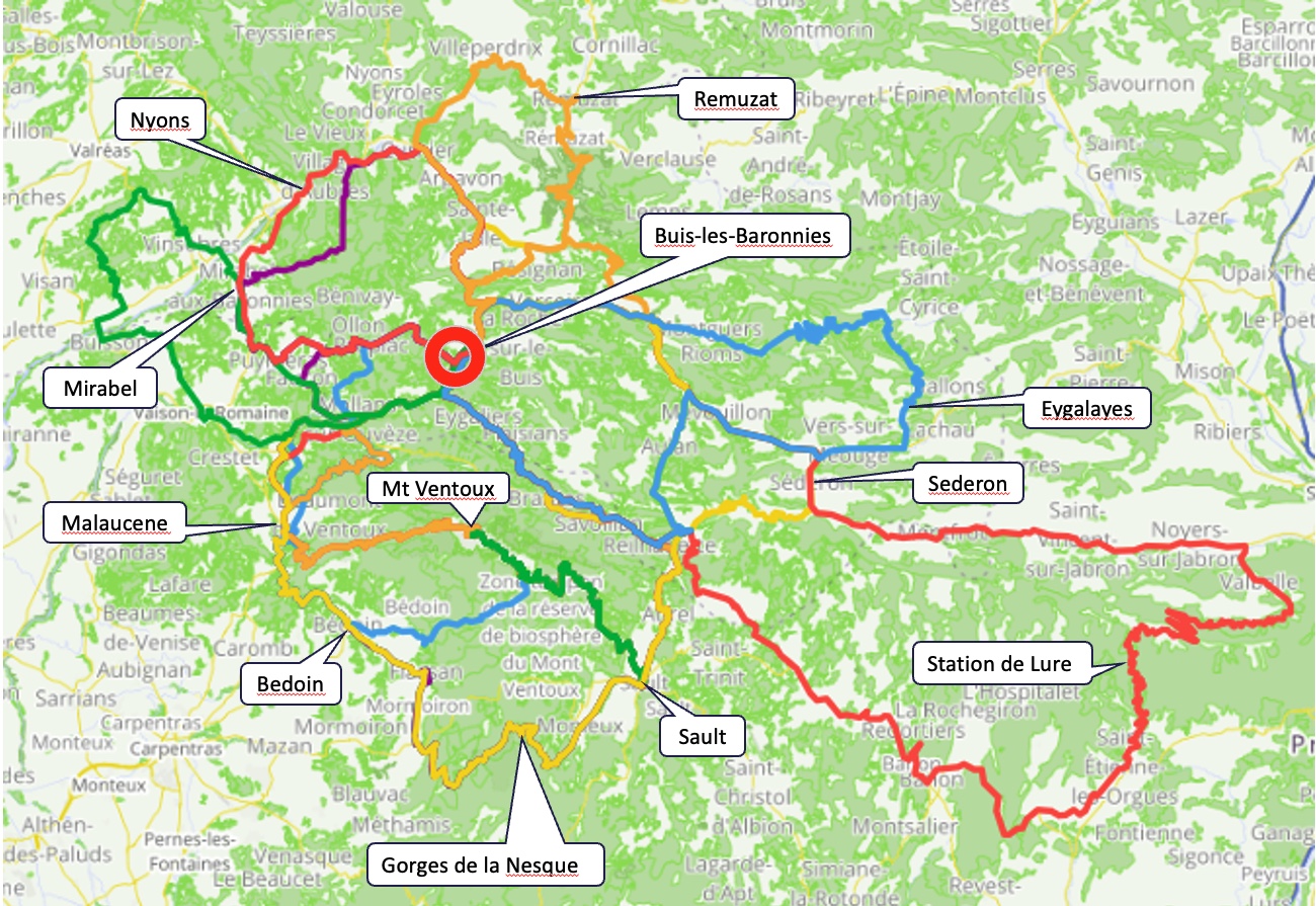
You will find on this page a link to the collection of 19 routes that I have created specifically for our holiday. Please feel free to review and download the routes from the collection or indeed from the links in the table that Guy has been kind enough to put together. His “Route Summaries” table contains additional routes that he has found of interest in the area. It also has summary distance/elevation details provided. There are 3x as many routes in my collection as there are riding days, so lots of choice. I’m hoping the variety of destinations and distances means that there is something for everybody, irrespective of riding capability and interest. Of course there is nothing stopping anybody from doing their own thing too, it’s your holiday after all.
Darren’s RWGPS Collection of routes:
https://ridewithgps.com/collections/57643?privacy_code=GKqmAP4XtH4iWWgA
Accompanying the routes is a ride description and cuesheet PDF. It lists all the routes giving:
- overview of the ride
- map of the route which includes ‘km’ markers and custom cues
- description of the ride
- route elevation profile
- cuesheet table that lists some possible cafe/drink/lunch stops and points of interest along the route (including in many places opening times)
- summary estimate of the ride length and total elevation (please note the elevation may not match the route itself, this appears to be a bug that I have reported to RWGPS Support)
I would recommend that you download all the routes to your GPS in advance of the trip, additionally download the cuesheet PDF to your phone. The custom cues (cafe/POI markers) will appear on your GPS as you ride, so no need to worry about trying to locate a cafe. However you will only get these custom cues if you are a premium/paid subscriber of RWGPS. To get around this and make it quicker and easier I have downloaded these to a zip archive. If you download this to a PC and plug in your GPS via USB then you can reliably and quickly transfer all of the routes directly to your GPS.
Instructions:
When you click on the routes-zip link it should prompt you to download the provence-routes.zip file to your computer. Once downloaded, unpack the zip archive (or simply open it); it will reveal a directory called routes containing the following files:
$ ls –size -1h routes| grep -n .
1:total 2.1M
2:180K Eygalayes_Loop.fit
3: 44K Faucon.fit
4:160K G-Nesque_CCW.fit
5:136K G-Nesque_CCW_Shorter.fit
6:132K Gorge_du_Nesque_CW.fit
7: 48K Malaucene.fit
8: 68K Mirabel.fit
9: 84K Nyons.fit
10: 20K Poet-en-Percip.fit
11:108K Remuzat.fit
12: 44K Sainte_Jalle.fit
13: 56K Saint-Sauveur.fit
14: 84K Sederon.fit
15:260K Sommet_de_Lure.fit
16: 96K Vaison-la-Romaine.fit
17: 76K Ventoux_up-down.fit
18:188K Ventoux_via_Bedoin.fit
19:148K Ventoux_via_Malaucene.fit
20:120K Ventoux_via_Sault.fit
If you plug in your GPS via a USB cable then it will show up on a MAC/Windows machine just like a USB removable storage/memory-stick.
Now use use your computer’s file explorer/file-manager to view the contents of the GPS (it will have some kind of drive letter on windows, no idea about MACs) you can navigate the directory hierarchy. One of the directories on the GPS will be called NewFiles (on Garmins). Copy all of the .fit files from the zip archive in to the NewFiles directory of your Garmin; make sure they go in this directory and NOWHERE else! Once the copy operation is complete, close the file manager and use your computer’s ‘safely remove USB storage’ button to eject the GPS (on Windows this is an icon in the bottom right of the screen). Once ‘ejected’, the computer will tell you that it is safe to unplug the device, so unplug the GPS and switch it on. It will take longer than usual to power up, this is because it has to process the 19 files. When eventually up and stable, you should see all of the routes/courses on the GPS. It’s normally a good idea to just view one or two of them to make sure everything is okay. At that stage you’re all set and ready to ride.
If anybody has a problem feel free to email me and I’ll try and help. I will be bringing a laptop away with me to Provence so can assist with the download if required, however I would prefer not to have to do this for 30 people!